It’s been a while since I last updated Talaria. (Almost three years, in fact.) Not for lack of ideas! I’ve got quite a long list of improvements I’d like to make. But life is just so busy, with work, daily routines, various hobbies and so many exciting projects!
Sometimes, however, an unexpected event can turn everything upside down. This is how I recently fell off my bike and broke my collarbone! As a result, my summer plans have changed from zig-zagging my trekking bike across the Pyrenees between France and Spain to finally making some long-planned improvements to Talaria (and sunbathing in my deckchair).
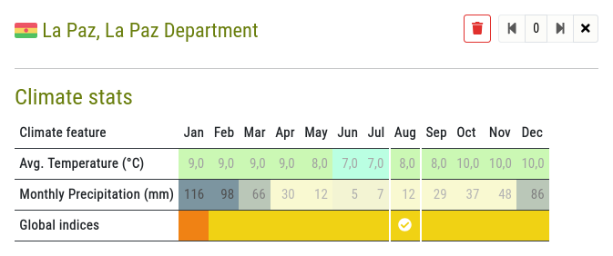
Weather Conditions
In particular, it had been a (really) long time since I wanted to revise the climate estimation system. This is one of Talaria’s key features, and I wasn’t entirely happy with how it worked.
Until now, the climate estimates offered by Talaria for a given location were based on the historical records of the nearest weather station. This station might be in a place that is not entirely comparable to the desired point (at a different altitude, for example), or it might not provide a very complete set of data. So, while Talaria’s climate estimates were already a good aid to preparing for cycling trips, they could sometimes be misleading.
The update consists of two main points:
- Instead of using data from a single weather station, the programme now compiles values from the few stations closest to the waypoint. If some data (such as temperature) is missing from the closest station, others are likely to provide it. Combining data from stations to the north, south or in any direction also allows for more balanced averages. What’s more, the programme doesn’t just calculate averages; it produces weighted results based on the distance from each station, giving more nuanced results. For greater clarity (and although it is now less useful), the list of reference stations is now shown in the detailed view of each waypoint.
- As the temperature also varies significantly with altitude (~6.5°C per 1000m), the weather station readings are now corrected for the altitude of the desired location. You’ll no longer think you can sleep on top of a mountain pass when the weather station is down in the valley!

All this means that Talaria’s climate estimates are now much more reliable. Keep in mind, however, that these are statistical averages (the typical conditions of a given location at a given time of year), which is not the same as a weather forecast. Talaria might tell you that it’s usually sunny in Prague in August, but on the day you travel through, it might be cold and rainy. That’s life!
In a second phase, I’d also like to look at how Talaria interprets all this weather data into comfort indices. But this is more of a fine-tuning issue, and most of the major misunderstandings have now been resolved. That other improvement might wait until I break another bone!
Other Updates
In addition to these changes, which I consider to be quite significant, Talaria has benefited from two less obvious, but still practical or promising improvements:
- On the page where your travel projects are listed, they can now be sorted by either their title or the date they were last modified, making it easier to find the one you want to work on. (This feature is only available if you have a certain number of projects, so as not to clutter the interface unnecessarily.)
- I’ve implemented a first draft of a backup and restore system for Talaria plans. At the moment it’s mainly a tool to help me develop the program, and only the list of waypoints is saved. (The marks or settings aren’t yet.) But in the future I plan to back up all data related to a project. I also intend to allow the import of GPX files. (I’ll definitely need to break a lot of bones!)
As always, feel free to share your thoughts and ideas, or report any bugs you find. You can do this either in the comments section of this page, or by using the contact form.